The Stormwater Quality Standards Task Force includes representatives from local counties, cities, environmental groups, the Santa Ana Water Quality Control Board, and others interested in water quality issues within the Santa Ana Watershed. The Task Force proposed a phased workplan to re-evaluate water quality standards as they relate to stormwater and dry weather flows within the watershed that are necessary to protect recreational beneficial uses.

The Task Force was formed in 2003 to assist the Regional Board in providing the scientific and technical basis for modifications to existing bacteria quality objectives for recreational uses. In addition to recommendations for new objectives based on the best available science, the Task Force work has led to recommendations for changes in recreational use designations and implementation strategies. The Task Force work effort includes basin-wide assessment of the current conditions of receiving waters, the nature of recreational uses, and areas where additional data or information are needed. The work of this Task Force has resulted in one of the Country’s most detailed photographic data collection efforts regarding recreational use. SAWPA serves as administrator of this Task Force.
Agendas and Meeting Materials
Basin Plan Amendment Supporting Materials
Regional Board Proposal to Amend Basin Plan
Task Force Reports and Technical Memos
- Draft – Dry Weather Diversion Memo – Orange County (8/2010)
- Draft – Dry Weather Diversion Memo – Riverside County (8/2010)
- Draft – Dry Weather Diversion Memo – San Bernardino County (8/2010)
- Verbally Describing Risk and Probability (5/2002)
- Task Force Axioms for Setting or Changing Stormwater Standards (2004)
- Great Lakes Bacteria Rule – Final (11/2004)
- Description of the Delphi Process (3/4/2004)
- Phase I Summary (1/2005)
Stormwater Quality Standards Study, Phase I Study Report January 2005
- Cover, Contents, Overview
- Technical Memorandum 1- Receiving Water and Watershed Inventory Mapping
- Technical Memorandum 2- Recreational Use Inventory
- Technical Memorandum 3- Flow and Water Quality Inventory and Characterization
- Technical Memorandum 4- Inventory and Analysis and of Existing Major Control Programs and Structural Measures
- Receiving Water Attribute Determination(11/28/2005)
- Flow Characterization(11/28/2005)
- Review of State Recreational Uses and Bacteria Objectives(12/12/2005)
- Scientific Basis for EPA Recommended Water Quality Objectives for Bacteria (4/10/2006)
- Economic Analysis of Compliance Alternative: Santa Ana Delhi(6/30/2006)
- Draft Upper Santa Ana Delhi Compliance Alternatives Analysis Technical Memorandum(11/29/2007)
- Dry Weather Document/Economic Analysis (November 23, 2009)
- Preliminary Draft High Flow Suspension Analysis Memo (March 3, 2010)
Recreational Use Surveys & Use Attainability Analysis Technical Reports
- Summary of Survey Camera Locations
- Recreational Use Survey – Demens Channel (7/2009)
- Recreational Use Survey – Perris Valley Channel (7/2009)
- Recreational Use Survey – Santa Ana River at Anaheim (7/2009)
- Recreational Use Survey – Chino Creek (7/2009)
- Recreational Use Survey – Cucamonga Creek (11/2006)
- Recreational Use Survey – Cucamonga Creek (7/2009)
- Recreational Use Survey – Anza Channel (4/2010)
- Recreational Use Survey – San Diego Channel (4/2010)
- Recreational Use Survey – Delhi (10/2006)
- Recreational Use Survey – Greenville-Banning (11/2006)
- Recreational Use Survey – Temescal (11/2006)
- Use Attainability Analysis Technical Report for Greenville-Banning Channel (8/2010)
- Use Attainability Analysis Technical Report for Temescal Creek (8/2010)
- Use Attainability Analysis Technical Report for Santa Ana Delhi Channel (8/2010)
- Use Attainability Analysis Technical Report for Cucamonga Creek (8/2010)
Other Documents
- Methods of Assessing Instream Flows for Recreation
- Regional Public Health Cost Estimates of Contaminated Coastal Waters (7/2006)
- Review of Epidemiological Studies for Freshwaters by David Woelfel (2/2006)
- Great Lakes Pathogen Rule (11/2004)
- Use of Wireless Video Cameras to subcategorize recreational use designations (2005)
- ASIWPCA Bacteria White Paper (11/2005)
- Great Lakes Epidemiology Study (1/2006)
- Improving Effective UAA Processes: US EPA (3/13/2006)
- EPA Water Quality Standards (Single Sample Maximum): EPA Fact Sheet (8/2006)
- EPA Water Quality Standards (Selection of Appropriate Risk Level): EPA Fact Sheet (8/2006)
Stormwater Documents
Recreational Use Survey – Chino Creek
Recreational Use Survey – Cucamonga Creek
Recreational Use Survey – Demens Channel
Recreational Use Survey – Perris Valley Channel
Recreational Use Survey – Santa Ana River at Anaheim
Draft Recreational Use Survey – Anza Channel
Draft Recreational Use Survey – San Diego Channel
Use Attainability Analysis Technical Report for Santa Ana Delhi Channel
July 7, 2009
Draft Use Attainability Analysis Technical Report for Santa Ana Delhi Channel
May 15, 2009
Preliminary Draft Use Attainability Analysis Technical Report for Santa Ana Delhi Channel
April 23, 2009
DraftUse Attainability Analysis Technical Report for Santa Ana Delhi Channel
October, 2009
Draft Use Attainability Analysis Technical Report for Cucamonga Creek
October, 2009
Draft Use Attainability Analysis Technical Report for Greenvile-Banning Channel
October, 2009
Draft Use Attainability Analysis Technical Report for Temescal Creek
October, 2009

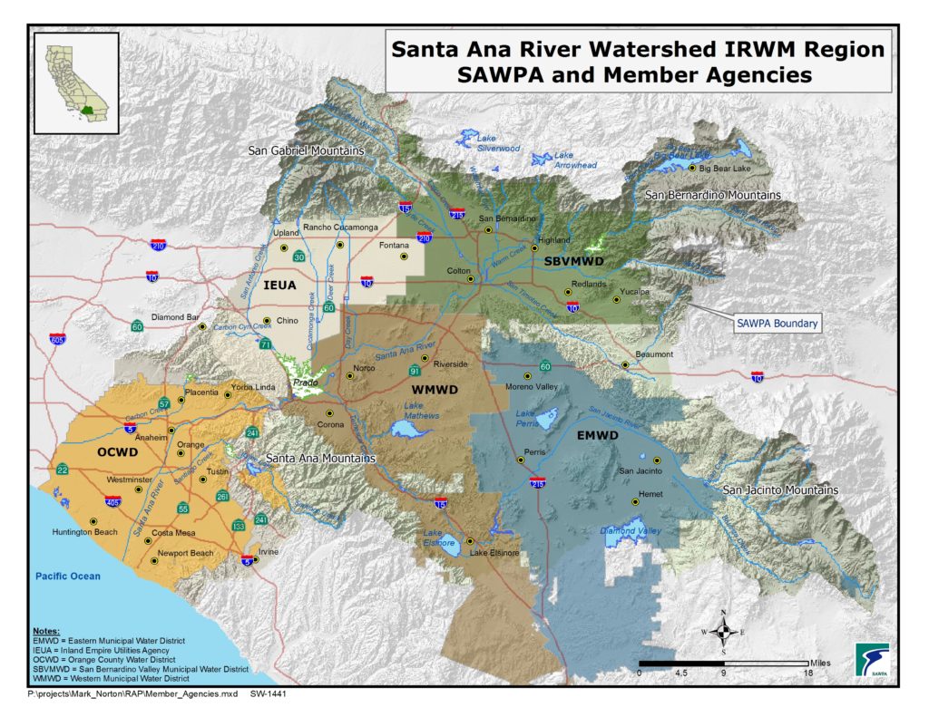
The Santa Ana River Watershed is located in southern California, south and east of the city of Los Angeles. The watershed includes much of Orange County, the northwestern corner of Riverside County, the southwestern corner of San Bernardino County, and a small portion of Los Angeles County. The EPA identifies the San Jacinto watershed as a separate watershed; for SAWPA’s purposes, the San Jacinto watershed is considered to be part of the Santa Ana River watershed. The watershed is bounded on the south by the Santa Margarita watershed, on the east by the Salton Sea and Southern Mojave watersheds, and on the north/west by the Mojave and San Gabriel watersheds. The watershed is approximately 2,800 square miles in area.

